Risk of Collision when Sailing
The Rule
- Every vessel shall use all available means appropriate to the prevailing circumstances and conditions to determine if risk of collision exists. If there is any doubt such risk shall be deemed to exist.
- Proper use shall be made of radar equipment if fitted and operational, including long-range scanning to obtain early warning of risk of collision and radar plotting or equivalent systematic observation of detected objects.
- Assumptions shall not be made on the basis of scanty information, especially scanty radar information.
- In determining if risk of collision exists the following considerations shall be among those taken into account:
- Such risk shall be deemed to exist if the compass bearing of an approaching vessel does not appreciably change.
- Such risk may sometimes exist even when an appreciable bearing change is evident, particularly when approaching a very large vessel or a tow or when approaching a vessel at close range.
Discussion
Here it is saying that you are fully responsible for determining if any risk exists and that you MUST use all available means to determine the risk. Part (c) says that you can’t make assumptions on scanty information i.e. you must be fully confident that the information you are receiving is 100% reliable.
Take an example of you failing to take the action of determining risk and a collision happened but fortunately, you were not the Give-Way vessel. This rule says that you are accountable for the collision.
Below we show what it means by a constant compass bearing of an approaching vessel. A compass bearing is more reliable than lining two points up on your boat because if the heading of your boat changes the line will change. Using a compass bearing – the bearing does not care if your heading changes. The bearing will remain the same.
Here is an animation of the same effect:
This is a good time to introduce you to AIS
In the United States and most other countries, all commercial traffic with gross tonnage above 300 tons and all passenger vessels are required to transmit AIS Data. AIS uses a digital VHF signal and stands for Automatic Identification System. With AIS you can get data on shipping traffic, the name of the vessel, the heading, speed, the GPS position, and other data. One piece of data to watch is the CPA. It sands for the Closest Point of Approach – meaning how close will the other vessel get to you. If CPA is close to zero then you have an issue. Also, TCPA is the Time until the Closest Point of Approach. You can see that an AIS device can be very useful.
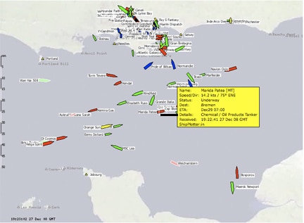
A good example of a real-time site showing AIS data. The image below is from this website and is of the Solent area in the south of the UK. You can hover over a ship with your mouse and get the information, which can help avoid collisions. Wikipedia has a good explanation of AIS.
Plot of Traffic in the Solent
Watch this video of a live explanation of the AIS technology.


