Sign up with NauticEd for FREE (no obligation) and receive 2 free boating courses, a free eLogbook and boating resume, and more! If you want to get started in boating or are experienced and want to expand your knowledge and skills, consider taking our many online sailing and powerboating courses.
Tides and the Rule of Twelves
Understanding Tides
Tides are often intimidating to sailors and so, many sailors tend to try not to sail in tidal areas or just ignore them hoping that if they stay deep enough there is little to worry about.
The point of this article is to de-intimidate you about tides by explaining the predictive nature and how to access information easily about the local conditions.
But first, let’s start with an intimidating situation to set the worst-case then we’ll take it up from there.
On a recent trip to the UK, we visited Ilfracombe on the southwest coast of England. This whole area and further up the coast towards Wales exhibits one of the highest tidal areas on the planet. Ilfracombe has a 9-meter tide – that’s 30 feet for imperial speakers. The point of the visit was to experience this, get the photo, and write about it. What we didn’t plan on was a real life-threatening situation – not really but sort of – close(ish) – kinda -could have gotten bad – well, at least wet. Read on.
Here is a pic of the tide just after high tide in Ilfracombe.

The tide is in – boats happily floating
Here is the same place a few hours later.
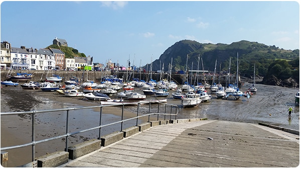
The tide is out – boats sitting on the bottom high and dry
9 meters – 30 ft is huge. Ilfracombe as a normal diurnal tide meaning there are two high tides and two low tides every day. From high tide to low tide is around 6 hours and 20 minutes. The rate of water movement for all that to take place over 6.3 hours is hard to conceptualize. As we walked along a flat beach – it seemed like every lap of the waves caused the water to progress up the beach about 6 inches. To experience it is an awesome wonderment.
Throughout the day as we watched, rocks covered and uncovered and some turned into rather large islands from nothing.
Not only is the vertical movement of the tide a concern, but the currents produced from the moving water is of a potentially greater concern. We went out fishing on a kayak and were constantly wary of our position moving relative to the land and of the swirling directions of the current flow. 300 meters out we were being pushed in one direction quite fast, 2-3 knots, but closer in we were drifting in the opposite direction at 1-2 knots. And most of the time it was hard to even get the line on the bottom due to the current. According to the extremely hospitable local, we stayed with and took us fishing, every year many people have to be rescued from the current. Mostly just due to the underestimation of the conditions. I’m a pretty good and fast swimmer, it takes me about 20 minutes to knock out 1 km in the pool with no waves. That’s swimming at about 1.5 knots. Thus even I would be swept out faster than I could swim.
So what actually happened was that one of our party climbed down onto some rocks to get a better place to fish. An hour later he turned around and was completely cut off from the land by the rising tide. Since it was about half tide the water level was rising quite quick and was pouring over a weir about 6 inches of flow height into a basin created by a walkway that was completely covered and thus stopping his escape. We saved his soul by dropping me off the two-person kayak onto land and Martyn returning to go get him. Actually pretty funny and I was grateful it happened to create the story here but… this is the stuff that you hear about. My friend was simply not used to and did not expect such conditions from any experience he has had in the past. Nighttime and a few waves and cold water and it could have been lights out.
Tides Explanation
This is the best explanation of tides we’ve ever seen. It’s done by the famous physicist Neil DeGrasse Tyson.
The Rule of Twelves
Slack water occurs at or close to high and low tide. At this time the water is hardly moving and so fishing and swimming can be safe (ish). The highest current times occur at or close to ½ tide. However, there is not a linear scale. It’s on a sinusoidal scale and is approximated by the following rule of twelve. First, the rule of twelves is not entirely accurate but it’s not a bad way to think about a rising or falling tide.
The tide rise and fall approximate a sinusoidal curve i.e it starts out slow then increases the fastest at about half tide then slows down to a very slow finish.
See the following animation (best viewed with Chrome or Safari). This is a tide rising over a 6-hour period using the rule of twelves as a basis for the tidal rise.
When you push the play button the rising tide goes slow and not much has happened in the first hour, But by 3 the tide is rising fast. In the last hour, the tide is rising to its final level slowly.
Thinking linearly, you would say that the tide has to rise 30 feet over approx. 6 hours that means 5 feet per hour. But the animation shows 2.5 feet in the first hour. Between 3 and 4 it averages 7.5 feet per hour and the last hour is 2.5 feet. This then is how the rule of twelves helps you approximate a tide in your head.
With the Rule of Twelves, you start out with 1/12th rise in the first hour. Then 2/12ths rise in the second hour then 3/12ths rise in the 4rd and 4th hour. Then back down to 2 /12ths in the 5th hour and 1/12th in the 6th hour.
This is an ok approximation to the sine curve. In addition, tides are only approximated by a sine curve. So realize when applying this rule, that it’s an approximation. But not too too bad actually.
In our Ilfracombe 30ft (9m) example here is what the rule of twelves looks like and assuming a 6-hour tide (which it is not there it is 6:20 between high and low tide)
|
End of hour |
12ths incr | total 12ths inc |
tide height ft |
|
1 |
1 | 1 | 2.5 |
|
2 |
2 | 3 |
7.5 |
|
3 |
3 | 6 | 15 |
|
4 |
3 | 9 | 22.5 |
| 5 | 2 | 11 |
27.5 |
| 6 | 1 | 12 |
30 |
Now in reality take a look at this below. This is a screenshot from the World Tides App for Ilfracombe on Sept 27, 2014. It shows an 8.1 meter (26.6 ft) tide rise on that day. Low tide is at 2:20pm and high tide is at 8:40 pm. The low tide is 1 meter above the printed chart reported datum. Thus the rise in height that day will be 8.1 meters. (Chart Datum in the UK and most of the world is set at the lowest attainable tide levels (LAT) in the USA it is set at Mean Low Low Tide (MLLW)).
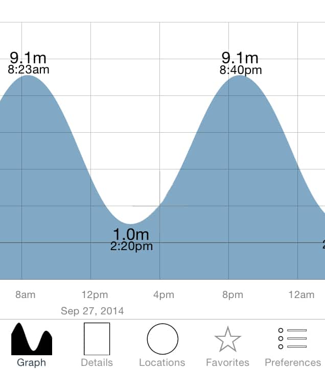
Tide at Ilfracombe on Sep 27th 2014
I then plotted the rule of twelves prediction on top of this tide shape. You’ll notice a fairly decent difference but not that much that discounts the rule of twelves.
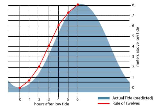
Tide with the rule of twelves plotted
Now in addition – note that the blue area rise and fall of the tide is as predicted and not actual. However, since tide data is so well known, you are well served by assuming the predicted tide will be very close to the actual. More on that in a minute.
More on the Rule of Twelves
We invented the Rule of Twelves calculator to allow you to determine tide height when you know the highs and lows and the times using the rule of twelve. Note that the rule of twelves assumes a diurnal tide system where there are two highs and lows each day of similar height.
De-Intimidating Tides
With a tidal App, you have accurate access to the tide heights at any time of the day in virtually any port in the world. You can see if the tide is coming in (flooding) or going out (ebbing). If you know your eta at a port then you can simply pull out your Tide App and see what height the tide will be.
There are many tidal apps out there and most navigation apps have tides embedded into them.
One good tidal App is the Worlde Tides App
Here’s the link for the iOS version:
World Tides 2022
And here is the same on the Google play store:
World Tides 2022
In addition – most tide Apps DO NOT need a connection to the internet after it is initially downloaded. The data is stored on your device. How is this so? Tides are wonderfully predictable and we have got them so figured out that the accuracy is usually within a few inches at any time. This is because for hundreds of years now we (humankind) have been measuring the height of the tide at points all over the world and comparing those measurements to the positions of the Sun and the Moon. Since the Sun and Moon exactly repeat their combined cycle every 19 years, the tides repeat themselves to the exact heights and cycles every 19 years. It took a lot of work from a lot of people BUT now we have it. Tide prediction is accurate and the data is at your fingertips 24/7.
Don’t be afraid of tides.
In our Coastal Navigation course, we have a very detailed discussion of tides going through the theory of prediction, how to predict at subordinate stations, and lots of discussion about how to handle current flow due to tides. It is the best Coastal Navigation course available.
Take our Coastal Navigation Course
Coastal Navigation Course
This Coastal Navigation Clinic is quite possibly one of the best values on the Internet. For just $39, you will fully understand the fundamentals of Coastal Navigation and be able to practically apply them wherever you go.
Bareboat Charter Master Course
*Includes Coastal Nav Course* Become a Bareboat Charter Master - a comprehensive online course for multi-day near coastal sailing and bareboat chartering internationally.
Start with 2 Free Sailing Courses
Sign-up and get 2 free courses and a free sailing eLogbook to build your sailing resume for charter companies worldwide.
Author
-
My vision for NauticEd is to ensure that families and friends get out on the water not only safely but with true COMPETENCE, confidently savoring every moment of their valuable time.
Achieving this means being the pinnacle of sailing and boating education—offering comprehensive multi-media theoretical instruction coupled with hands-on, on-the-water training through our global network of American National Standards Instructors. We steadfastly avoid becoming a mere certification mill; our focus is on delivering genuine competence, ensuring our students are well-prepared for enjoyable, real-world boating experiences.
View all posts
You might also like
NauticEd is a fully recognized education and certification platform for sailing students combining online and on-the-water real instruction (and now VR). NauticEd offers +24 online courses, a free sailor's toolkit that includes 2 free courses, and six ranks of certification – all integrated into NauticEd’s proprietary platform. The USCG and NASBLA recognize NauticEd as having met the established American National Standards. Learn more at www.nauticed.org.
The NauticEd Vacations team are Expert Global Yacht Charter Agents – when you book a sailing vacation or bareboat charter through NauticEd, we don’t charge you a fee – we often save you money since we can compare prices from all yacht charter companies. PLUS, we can give you advice on which destination or charter company will suit your needs best. Inquire about a Sailing Vacation or Charter.


