How to Get to a Waypoint
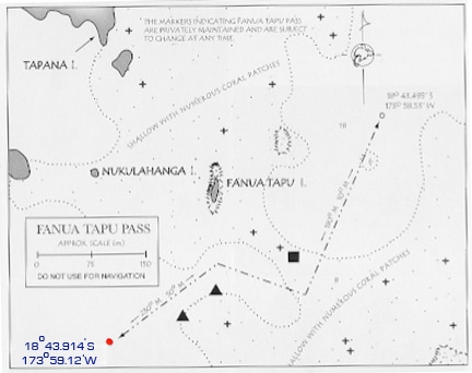
Recently on our NauticEd flotilla with the Moorings to the Kingdom of Tonga we wanted to pass through the Fanua Tapu Pass which is a gap in the reef to get to the eastern islands of the Vava’u archipelago. Normally the gap is marked by a series of buoys, however the latest storm ate them.
The pass is well documented by two waypoints. Traversing using a GPS map, however, was out of the question because Tonga is one of the last places on earth to be accurately placed on the world coordinates. Yes you’re reading that right – the islands are not actually where the maps say they are and especially reefs and rocks are not where they are positioned on the maps. That’s pretty absurd for this day and age but it’s true. Call the Moorings base in Tonga for your self.
Navigation is performed using good old eyesight (some of our eyesights are older than others) coupled with map reading skills, a depth sounder and a keen watch out on the foredeck.
So anyway we had to get the first waypoint dead on to pass through the reef. The first waypoint was 18 deg 43.914 min South and 173 deg 59.12 min West. Our position was 18 deg 44.902 South and 173 deg 62.014 West.
So it’s a bit funny trying to hit a point like this because you’ve got to be able to work with a few obvious things but understanding the principles makes it much easier. First you’ve got to know which directions you need to be heading based on the hemispheres you’re in.
In the northern hemisphere to increase the latitude you’ve got to head north but in the southern hemisphere to increase latitude you’ve got to head south.
Similarly, in the eastern hemisphere to increase longitude you’ve got to head east where as in the western hemisphere to increase longitude you’ve got to head west.
OMG how do you remember that? Especially in the heat of the moment with waves and rocks all around you and your life depending on it.
I’m sure there is a memonic for it but it’s best to understand the principle first and below is the way where I can best understand it. For me, I find that principles are better than memonics.
Imagine you’re standing on the intersection of the prime meridian (below grenwich) and the equator. You’re at 0 deg Latitude and 0 deg Longitude. Move in any distance to the North and the latitude increases North. Move any distance to the South and the Latitude increases South. Now place yourself at about 17 degrees south latitude. Move North and you’re moving towards the equator and towards 0 deg Latitude.
So in principle then, if you understand this; move towards the equator you’re decreasing the Latitude no mater which north or south hemisphere you’re in. So in our example above our latitude was greater than the waypoint so we needed to head towards the equator. We were in the southern hemisphere so we needed to head north.
IE when dealing with latitude – just figure out if you need to head towards the equator or not. That should take care of that from an understanding principles point of view.
Longitude. Back to our Prime Meridian/Equator intersection. Looking towards the North pole, everything towards your left is West Longitude right? And everything towards the right is East Longitude. So anything from England, past the Americas and all the way around to Hawaii is West longitude. Any everything from England, past Asia and all the way to Australia and New Zealand is East Longitude. This is why the USA is known as western society and Asia is known as eastern society.
So now you just got to know where you are East or West. In Tonga we were on West Longitudes. So anything back towards the Americas or England from that point was decreasing the Longitude numbers towards the zero prime meridian in Grenwich. Which meant to get to our waypoint we had to head East to the America’s.
So overall we needed to head to the North and to the East. Next we looked at what was the relative differences between desired and present positions for latitude and longitude. The longitude difference was about 3 times that of the latitude difference. This means we needed to head more east than north.
In the old days (I mean the old old days) before longitude could accurately be determined, traders would head north from Africa and purposefully miss England far far to the west of England. Then once on the latitude (easily discovered by the angle the north star makes with the horizon) they would then travel East. This ensured they would miss all the potential dangers. Hundreds of ships were being lost due to the difficulty in accurately determining the longitude. In early 1700’s the King of England offered a 10,000 pound reward to figure out how to accurately determine Longitude. For those of you interested, watch the history channel show on this or read the book “Longitude”. Both are excellent!
So lets go back to the principle. Where ever you are you should establish this before any issues come up. IE if you’re on a bareboat charter – answer these questions before you leave the base.
Am I in the southern or northern hemishere? Then based on that, embed into your head which way do you go to increase/decrease latitudes. Should you head towards the equator or away.
Am I in Eastern Longitudes or Western Longtiudes? Then decide which continent you should head to decrease or increase longitudes.
Here’s a little test then. You’re in the Aegean Sea at:
36 deg 56 min North Latitude, 27 deg 19 min East Longitude
you want to get to:
36 deg 57.897 min North Latitude, 27 deg 17.295 Min East Longitude.
Which way should you be heading?
Simple enough – we’re in the North Eastern hemisphere. We want to increase the latitude so we need to move away from the equator and thus head north. We also want to decrease the longitude and head towards Grenwich England which means head west.
Both are almost 2 minutes in difference and so the VERY APPROXIMATE direction should be North East. We say VERY APPROXIMATE because the latitude lines and longitude lines are not the same distance apart and vary according to latitude. The closer to the poles the closer are the longitude lines. Therefore the heading would be more north of northeast.
In this blog we’re placing quite an importance on this concept. The reason being is a funny (potentially not so funny) story attached. On the Tonga trip one of the crew was an ex Airforce Navigator. He got turned around for a second in the reef because we were heading east to reach the waypoint but his brain was telling him to head west. The reason is that he was used to Navigating around New Zealand which is in the Eastern Longitudes. Tonga is just on the otherside of the 180th Meridian in the Western Longitudes. Whoops being turned around in the middle of reefs is NOT good. There were rocks all around us and correct decisions had to be made fast.
OK and here’s a real scenario to scare you into taking this blog and the NauticEd sailing simulator serious. A family member falls overboard at night and you hit the MOB button on your hand held GPS. You’ve got the lat and long where they went over. By the time you get turned around and the sails down with all the confusion – all you’ve got is their lat and long and yours and a compass. How do you save your family member’s life?
MOB is at 16 deg 33.250 min N and 62 deg 11.501 W
You are at 16 deg 33.200 min N and 62 deg 11.595 W
Which way do you head? Quickly now the current is drifting them away from that position.


