Tides and Coastal Navigation
ATTN: The NauticEd Coastal Navigation Course has been upgraded and updated. See below.
If you like that we update things for free, LIKE us over there —->
Snap Test:
(1) At Eastport, Maine. What was the max spring high tide height after the eclipsed super full moon on September 28th 2015. What was the min spring low tide and was it below the datum? What will be the height of the tide at noon today – Oct 5th?
(2) You live in SanFrancisco. You’ve got friends in town and you want to take them sailing today. What are the best times to take them out of the Bay under the Golden Gate bridge and back?
(3) How often does a spring tide occur and how could you predict it?
(4) Can the water level ever get below the chart datum? Why so or why not?
ANS: posted below – see where we got these plots (in less than 10 seconds)
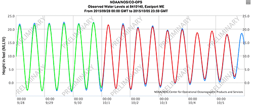
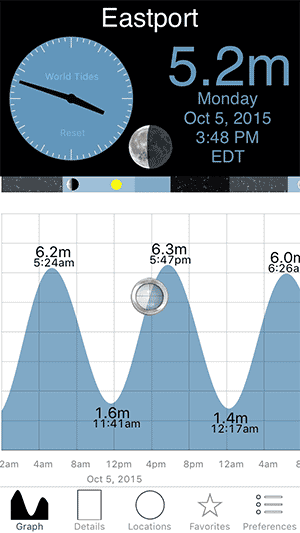
(1) The Max was 22.424 ft at 1700 GMT = noon EST 2 days after the full moon. The min was minus 1.818 feet (below the datum) at 23:30 GMT (6:30pm EST).
(2) The prediction is 3.675 above the datum
(3) Best go at low water slack time as the water will be flowing back into the bay after you dawdle around outside the bridge. This is right at about noon. See https://tidesandcurrents.noaa.gov/waterlevels.html?id=9414290&units=standard&bdate=20151005&edate=20151006&timezone=LST&datum=MLLW&interval=6&action=
(4) The USA sets the datum at MLLW which is the mean of the spring low tides over the 19 year cycle lunar solar. UK and the rest of the world set the datum at LAT which is the lowest astronomical tide meaning it should be the lowest it could ever get over the 19 year cycle. Thus often using MLLW the water level can drop below the datum. Using LAT it is less likely but can still happen.
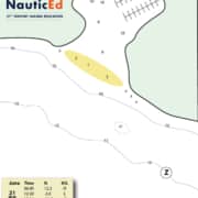
The above images were taken from https://tidesandcurrents.noaa.gov/stations.html?type=Water+Levels and the WorldTides 2015 iOS App respectively.
These questions are a breeze when you know what you are doing and the data answers are at your finger tips on your phone or on the Internet within seconds, if you know what you are doing.
One of the really cool things about eLearning software is that you can upgrade a course on demand – you can do a big update or a little one and the update goes instantly to your students. You don’t have to wait until the inventory is sold out and you don’t have to leave schools holding old inventory to be thrown out.
Last week we did a huge upgrade to the Coastal Navigation course. Mainly because we added in lots of new technology about tides and currents but we also added better explanations of plotting courses using animations.
Understanding of tides and currents have come a long way and websites have been automated to include instant data and tide predictions. Older courses and textbooks make you rely on looking up charts (on paper) – but why would you do that on a daily basis when the exact data is at your finger-tips. Off course, you must understand the fundamentals and we teach that but now we also give you access and knowledge on how to use apps and websites for instant data. It’s what a modern sailing course should do!
Students who have taken our older course now have the benefit of the new course at no cost. Just sign in to NauticEd now and go. You can retake the tests and get up to date on latest coastal navigation techniques and understanding.
Take the NauticEd Coastal Navigation course now for $39.
Learn the theory of course plotting, how to do it and make it second nature, how to measure distances, predict ETAs, account for current flow in course plotting, calculate current flow rate and direction, determine water depth relating to tide, best times for harbor entry, understand GPS, using parallel rulers, bretton plotters, buoys-markers-ATONS (aids to navigation), lights etc etc. Lots and lots of real examples and plotting challenges. You use a real chart. At the end of this course you will have completed the World’s most up to date Coastal Navigation Course and will fly through any other required course like the USCG Commerical Captains License navigation course.
Get free updates for life. Access the course for life. Take the test as many times as you want.
Take the NauticEd Coastal Navigation course now for $39.
Oh and the other cool thing we did was to add in the requirement to have passed either the FREE Navigation Rules course or the Navigation Rules Module in the Skipper (or RYA Day Skipper) course. This ensures everyone taking this course is up to date on Navigation Rules. It was the responsible thing to do. We did this by adding this piece of code to our software.
IF FREE Navigation Rules Course = Passed
OR IF Skipper Course OR RYA DAY Skipper Course = Passed
AND IF Coastal Navigation Course = Passed
THEN Add Coastal Navigation to the Certificate and the Resume

